|
Volcanoes of Terceira Island
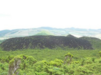
Furnas do Enxofre is the unique fumarolic field known at Terceira Island. It is located at Pico do Galhardo, a trachytic dome emplaced where the north /west and south/east basaltic ridge intersects Pico Alto Volcano.
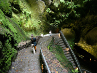
Furnas do Enxofre (sulphur pits) Caves Where there are volcanoes, there are caves - and the Azores have spectacular caves in profusion. More than 200 have been discovered.
Serreta Volcanic Ridge
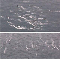
An oceanographic mission supported by the national Foundation for Science and Technology was carried out in April 1999 to study the geological/geophysical characteristics of the eruption and its impact on local ecosystems. Scientists from the University of Azores, University of Lisbon, University of Algarve, Instituto do Mar, and Instituito Hidrográfico used a remotely operated vehicle that crossed an impressive submarine volcanic plume just above an active eruptive center at about 380 m depth. This plume was formed by volcanic particles of ash and lapilli size along with gas bubbles and lava balloons up to 2 m in diameter. Don Joao de Castro Bank Don Joao de Castro Bank is a large submarine volcano that rises to within 14 m of the sea surface roughly halfway between Terceira and San Miguel Islands. A submarine eruption during December 1720 produced an ephemeral island that attained a length of 1.5 km and an altitude of about 250 m before it was eroded beneath the sea surface two years later. The volcano (also spelled Dom Joao de Castro) was named after the Portuguese hydrographic survey vessel that surveyed the bank in 1941. Two youthful parasitic craters, one tephra covered and the other sediment free, are located on the NW flank. The submarine volcano has an impressive fumarole field and remains seismically active.
Caldeira de Santa Bárbara An attractive trip can be made to the volcanic western part of Terceira and the Caldeira de Santa Bárbara (1,022m/3,353ft), the highest point on the island, a volcano with a number of explosion vents and collapsed craters. Northeast and east of the volcanic plateau, between Pico Alto, Pico da Bagacina and Furnas do Enxofre, are several crater lakes and fumaroles.
Slowly climbing up the slopes of Serra de Santa Bárbara, this scenic road leads through magnificent landscapes, with Japanese cedars and colourful hydrangea bushes dominating the views on the lower levels. With about 8 kilometres in diameter, this volcanic massif, which once created the western part of the island, encircles the lush green crater of the same name on its southwest side. With 1,021 metres above sea level the island’s highest peak, the volcano of Santa Bárbara marks the southern rim of the Caldeira de Santa Bárbara, which has a diameter of around 2 km, and a depth of only 150 m, with several small volcanic cones protruding from its bottom. A well-indicated asphalted road leads up to the top of the dormant volcano - which was last active in 1867 when the lava streams from a lateral flank badly damaged the village of Serreta - where a beautiful belvedere provides superb panoramic views making it possible to see the outlines of the neighbouring islands Graciosa, São Jorge and Pico on the horizon on clear days. The about 827 m high Pico Rachado marks the northern rim of the caldera and in the north-eastern part of the Serra lies the small and tranquil Lagoa Negra, much visited by migrating birds during the winter. Four small volcanic cones in the southeast of the volcanic massif form the area of the Mistérios Negros, part of it was only created during the eruption of 1761, which explains the rather scarce vegetation in this area.
Not suitable for bathing but ideal for picnics and meditation surrounded by beautiful lush green nature and divine tranquillity, the small, idyllic lakes of Lagoa do Negro, below the western flank of the 662 m high Pico Gordo, and Lagoa das Patas, also called Lagoa da Falca, at the bottom of the volcano Santa Barbara on the road near the Pico das Duas, are worthwhile a halt and spending some relaxing time there. Right next to the lake do Negro lies the entrance to the Gruta do Natal, an almost 700 m long, tunnel-like grotto where every year on Christmas day a mass is said, hence the name (‘Natal’ which means Christmas in Portuguese). |